

| |
|
|
|
|
|
|
Map by Conal Kelly
The elections for Northern Ireland's 11 local councils will take
place on 18 May, 2023. The poll is delayed by two weeks due to the
coronation of King Charles III on 6 May. When nominations closed
on 24 April, there were 807 candidates registered; down from 819
in 2019. Belfast, with its ten electoral areas, has the highest
number of candidates at 121, while Mid and East Antrim has the
fewest at 59. The party with the highest number of nominees is
Sinn Fein with 162, followed by the DUP with 152, the Alliance
with 110, the UUP with 101, and the SDLP with 86.
These are the third local government elections to the eleven
“super councils” established in 2012. The results of the last
elections in 2019 can be found below. The new councils superseded
the twenty-six local government districts established in 1973,
which formed the basis of ten elections between 1973 and 2011. You
can look at all the local election results since 1973 here, and compare specifically with
the 2019
elections here, the 2014 elections
here, the 2011 elections
here, the 2005 elections
here, the 2001 elections
here, the 1997 elections
here and the 1993 elections
here. (See spreadsheet
archive.)
| Party |
Seats 2019 |
Votes (Total) |
Votes (%ge) |
Seats 2014 |
Seats Change |
%ge Change |
| Democratic Unionist Party | 122 | 163,615 |
24.1% |
130 |
-8 | +1.0% |
| Sinn Fein | 105 |
157,448 |
23.2% |
105 |
0 |
-0.9% |
| Ulster Unionist Party | 75 | 95,350 |
14.1% |
88 |
-13 |
-2.0% |
| Social Democratic Labour Party | 59 | 81,419 |
12.0% |
66 |
-7 | -1.6% |
| Alliance Party | 53 |
77,742 |
11.5% |
32 |
+21 |
+4.8% |
| Traditional Unionist Voice | 6 | 15,165 |
2.2% |
13 |
-7 | -2.3% |
| Green Party |
8 | 14,284 |
2.1% |
4 |
+4 | +1.2% |
| People Before Profit | 5 | 9,478 | 1.4% | 1 | +4 | +1.1% |
| Aontu | 1 | 7,459 | 1.1% | 0 | +1 | |
| Progressive Unionist Party |
3 |
5,338 |
0.8% |
4 |
-1 | -1.2% |
| UK Independence Party | 0 |
3,026 |
0.4% |
3 |
-3 | -1.1% |
| NI Conservatives | 0 | 1,364 | 0.2% | 0 | 0 | -0.2% |
| Labour Alternative | 1 | 880 | 0.1% | 0 | 0 | |
| Workers Party | 0 | 871 | 0.1% | 0 | 0 | -0.1% |
| Democrats and Veterans | 0 | 527 | 0.1% | 0 | 0 | |
| South Belfast Unionists | 0 | 233 | 0.03% | 0 | 0 | |
| CISTA | 0 | 101 | 0.01% | 0 | 0 | |
| Independents | 24 | 43,686 | 6.4% | 15 | +9 | +2.2% |
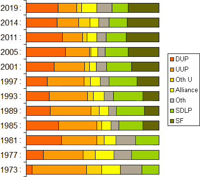
The graph below contrasts the first preference votes across the whole of Northern Ireland with those cast in the local government elections of 2019, 2014, 2011, 2005, 2001, 1997, 1993, 1989, 1985, 1981, 1977 and 1973.
| Council | DUP | UUP | TUV | Alliance | Others | SDLP | SF | Total |
| Antrim & Newtownabbey | 14 | 9 | 0 | 7 | 1 Ind | 4 | 5 | 40 |
| Ards & North Down | 14 | 8 | 1 | 10 | 3 Green, 3 Ind | 1 | 0 | 40 |
| Armagh, Banbridge & Craigavon | 11 | 10 | 0 | 3 | 1 Ind | 6 | 10 | 41 |
| Belfast City | 15 | 2 | 0 | 10 | 2 PUP, 4 Green, 3 PBP | 6 | 18 | 60 |
| Causeway Coast & Glens | 14 | 7 | 0 | 2 | 1 PUP, 1 Ind | 6 | 9 | 40 |
| Derry & Strabane | 7 | 2 | 0 | 2 | 4 Ind, 2 PBP, 1 Aontu | 11 | 11 | 40 |
| Fermanagh & Omagh | 5 | 9 | 0 | 1 | 1 CCLA, 4 Ind | 5 | 15 | 40 |
| Lisburn & Castlereagh | 15 | 11 | 0 | 9 | 1 Green | 2 | 2 | 40 |
| Mid & East Antrim | 15 | 7 | 5 | 7 | 3 Ind | 1 | 2 | 40 |
| Mid-Ulster | 9 | 6 | 0 | 0 | 2 Ind | 6 | 17 | 40 |
| Newry, Mourne & Down | 3 | 4 | 0 | 2 | 5 Ind | 11 | 16 | 41 |
| Total | 122 | 75 | 6 | 53 | 42 | 59 | 105 | 462 |
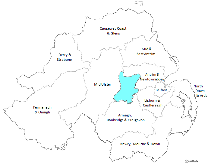
The ward is the primary unit of electoral geography and represents the building blocks for the local government districts. A ward cannot be divided between districts and must be contiguous to at least one other ward within the district (except where the ward consists of an island). Northern Ireland is divided into 462 wards. The number of wards designated per district is as follows: Belfast has 60 wards; Armagh, Banbridge and Craigavon district and Newry, Mourne and Down district both have 41 wards; the remaining eight districts have 40 wards each. The number of wards a district has is the equivalent of the number of councillors to be elected. The map of the electoral wards is outlined below:
Map by Conal Kelly
The District Electoral Area (DEA) is a distinct territorial subdivision of the local government district. It is comprised of between five and seven wards and is the focus of separate electoral contests. Northern Ireland is divided into 80 DEAs. They comprise 34 five ward areas; 30 six ward areas; and 16 seven ward areas encompassing all 462 wards. Each of the local government districts consists of seven DEAs with the exception of Belfast which has ten. The map of the new district electoral areas is outlined below:
Map by Conal Kelly
See also:
Other sites based at ARK: ORB (Online Research Bank) | CAIN (Conflict Archive on the INternet) | Northern Ireland Life and Times Survey
Your comments, please! Send an email to me at nicholas.whyte@gmail.com.
Updated by Conal Kelly, 1 May 2023.
|
|
Disclaimer:© Nicholas Whyte 2005 Last
Updated on Tuesday, May
10, 2005 23:32:51
|